I decided to hike up Sugarloaf Mt. in Wicklow Cty on Wednesday. I took the bus, crossed the bridge and immediately stopped into the post for directions to the "trail head." (Blogger won't recognize that the post pic is already rotated clockwise on my computer...but wanted to display the name of the town the base starts). Turns out there is no trail head or markers...Your man told me to walk up the road hill for some time (turned out to be an hour with little to no shoulder. I had to step off the road whenever a car drove by so not to get run over) till it leveled off (which it did about 5-6 times along the way). I would then come to an abandoned petrol station on my left...just go into the lot and 100m up there will be a "well worn path" "Ya caint missit!"
Turns out the abandoned petrol station was a run down farm and I had to go through two closed gates to get to the path...this was all after stopping a car to ask for directions when I was finally at my wits end! Mind you, this was the recommended back way...b/c the front path is nearly impossible to find unless your from around there and involves frequently crossing over farmer's private land.


Yes, yes...thisildoo just fine indeed!
(the name of someone's home)

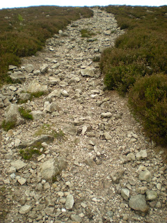
Once I finally found the "well worn path" this was it's progression. The trail going up the back side of Sugarloaf eventually met up with the front trail, which was a much more impressive view of the mountain. Quite steep and windy, so I decided to only go up halfway...will hike it again with Chris.


Making my way down... I decided to try to find my way down the front trail, as I didn't want to risk my life again on the roadway. I took many wrong turns and hit many dead ends.


It's never a good sign when one of the "trail markers" is a skull...But I made it out safely. Realizing more and more that America's idea of a hiking trail is not the same as the Irish' Round trip took roughly 3 hours.


.JPG)


.JPG)
.JPG)
.jpg)
.JPG)
.JPG)
.jpg)


.JPG)
.JPG)
.JPG)


.JPG)
.JPG)
.JPG)
.JPG)
.JPG)
.JPG)
.JPG)